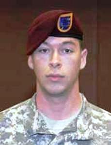
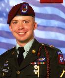
Spc.
Jonathan
David Arthur
"J.D." Emard
of Terrell
joined the
Army in
March 2006,
when he was
a
17-year-old
high school
senior.
He became an
Airborne
Ranger
assigned to
1st
Battalion,
87th
Infantry
Regiment,
1st Brigade
Combat Team,
10th
Mountain
Division
based in
Fort Drum.
N.Y., and
was deployed
to Iraq last
August.
/font>
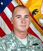
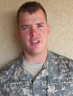
Spc. Emard,
Sgt. Shane
P. Duffy,
22, of
Taunton,
Mass., and
Sgt. Cody R.
Legg, 23, of
Escondido,
Calif., all
died of
wounds they
received
when their
unit was
attacked by
enemy forces
in Sharqat,
Iraq.
"They were
in a pretty
heavy
mission,"
said his
mother,
Debbie Emard
of Terrell.
"There was a
purpose: he
was doing
his job in
defending
his country
and family."
Services for
Spc. Emard
were held at
Lake Pointe
Church in
Rockwall. He
was
buried in
Dallas-Fort
Worth
National
Cemetery in
Dallas.
Born in
Dallas, Spc.
Emard grew
up in
Garland and
Terrell. He
attended
Garland
Christian
Academy and
public
schools in
Terrell. He
was a
freshman at
Quinlan Ford
High School
and
transferred
to Boles
High School
in Quinlan,
Texas.
Spc. Emard's
family
understands
that his
military
decorations
will include
a Purple
Heart with
two Oak Leaf
Clusters,
signifying
he had been
wounded
three times,
and a Bronze
Star. They
are awaiting
official
notification
of his
honors.
In addition
to his
mother, Spc.
Emard is
survived by
his father,
David Emard
of Terrell,
his sister,
Jennifer
Marler of
Terrell and
his
grandmother,
Jean Emard
of Garland.